
The Mouzon Map of the Carolinas, 1777
March 2014
An Accurate Map of North and South Carolina with their Indian frontiers, shewing in a distinct manner all the mountains, rivers, swamps, marshes, bays, creeks, harbours, sandbanks and soundings on the coasts, with the roads and Indian paths; as well as the boundary or provincial lines, the several townships and other divisions of the land in both the provinces; the whole from actual surveys by Henry Mouzon and others . . .
One of the treasures held in the special collections of Presbyterian College is the map named above which was compiled by William Henry Mouzon, Jr. based on his 1771 survey of South Carolina and surveys completed prior to that time by other cartographers.
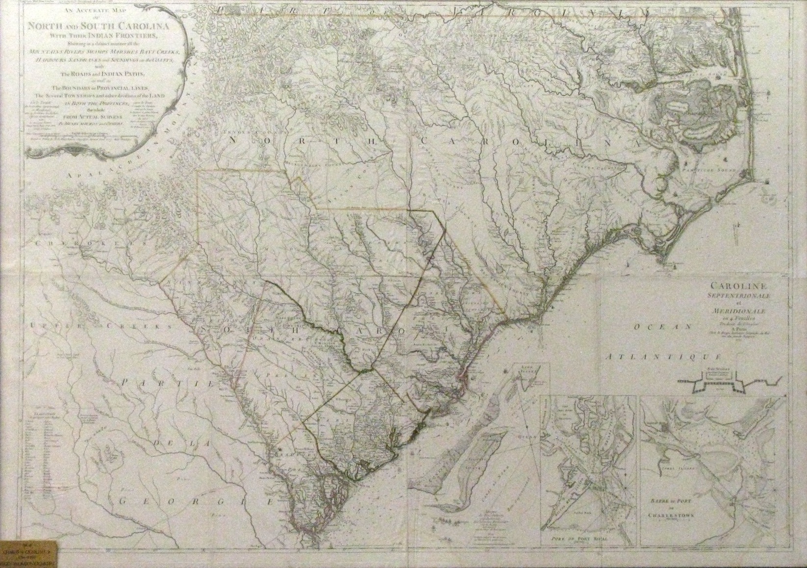
Mouzon’s 1777 map of the Carolinas
Note three inset maps in this 2nd edition
~click image to enlarge~
An Accurate Map of North and South Carolina was Henry Mouzon’s lifetime masterpiece. He was the grandson of Louis Mouzon, a Huguenot immigrant from France to South Carolina around 1705. Henry was born in 1741 on the north side of the Santee River at Pudding Swamp, Craven County, now known as Williamsburg County, SC. At the age of eight, Henry’s father died and he was sent to France for the remainder of his education. There he studied map making and civil engineering. Upon his return to South Carolina, he was appointed by Governor Lord Charles Greville Montague to survey the boundaries of the civil districts of South Carolina. He produced several smaller maps of South Carolina when Mecklenburg and Tryon were added to the province. He also surveyed the westward extension of the boundary between the two states in 1772.
Mouzon had originally planned to produce a new map of South Carolina with Ephriam Mitchell in order to correct inaccurate details they discovered during their surveys of South Carolina in 1771. Apparently, Mitchell withdrew from the project and Mouzon proceeded to plan an original map of the colonies of both North and South Carolina “by consolidating James Cook’s 1773 map of South Carolina with John Collet’s map of North Carolina. Mouzon drew on his recent surveys in order to show district lines in South Carolina with greater accuracy and to delineate the 1772 western extension of the boundary between the two colonies.” He corrected faulty perspective in the watercourses and major rivers in the maps of Cook and Collet, as well as the soundings along the North Carolina coast, placing names of the North Carolina counties so they would agree more completely with their physical boundaries. (Dictionary of North Carolina Biography, UNC Press, 1991)
The first edition of Mouzon’s map of North and South Carolina which was published in London in 1775 by Sayer and Bennett included two inset maps detailing Charleston and Port Royal. The second edition of this map, owned by Presbyterian College, was published in 1777 in Paris by George L. LeRouge, a royal geographer. It is titled in French and English and includes a third inset map detailing the British attack on Fort Sullivan on June 28, 1776 [Attaques du Fort Sulivan près Charlestown dans la Caroline Méridionale par les Anglois le 28 Juin 1776 avec les camps des Amériquains]. Several British ships are represented and named off the coast of Sullivan’s Island in the third inset map. For more information on this attack, see Fort Moultrie and the Battle of Sullivan’s Island from the Charleston County Public Library.
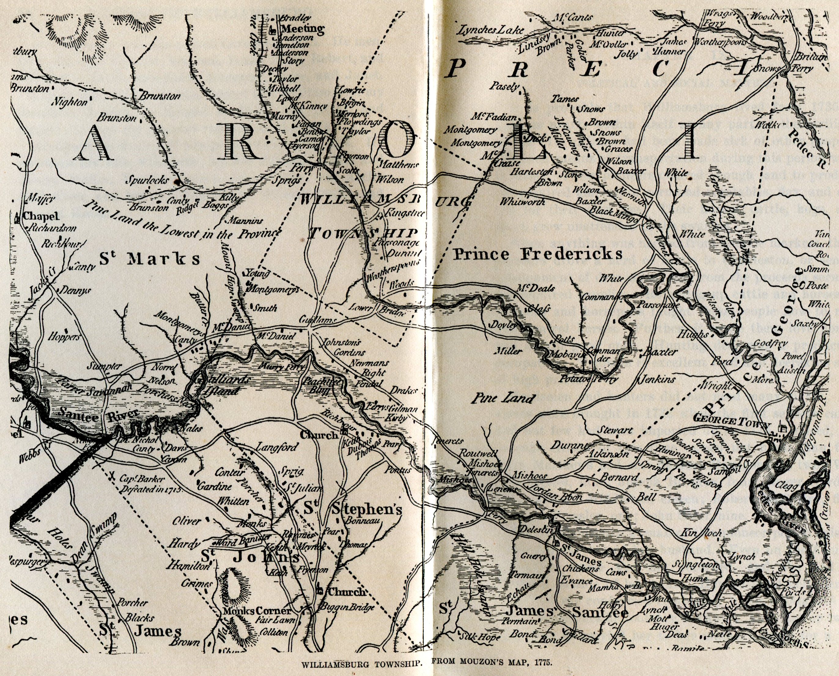
Note family names along rivers and creeks.
Detail of Mouzon’s map published in Boddie’s History of Williamsburg, The State Co., Columbia, 1923.
~click image to enlarge~
In addition to the inset maps detailing the coastline of South Carolina in the 1770s, another historical jewel is the addition of the surnames of families that had settled along the rivers and creeks by that time. On the right is a portion of Mouzon’s first map which was published in History of Williamsburg by William Willis Boddie in 1923. Click the image for a closer view of family names in Williamsburg Township. Kingstree is located south of the large “O” in Carolina in the center of the township. Also of note on this map is the designation of Native American villages and territories.
Mouzon’s map of North and South Carolina was used by American, British, and French forces during the American Revolution and remained the most authoritative map for North Carolina until the 1808 publication of Price and Strother’s map. In 1777 a map of this size, 61 x 45 inches, was produced on four sheets which were later connected, as was our copy of the map. It is said that George Washington’s copy of this map was affixed to cloth and could be folded up and placed in his saddlebag. Today, Washington’s copy is held by the American Geographical Society headquartered in New York City, Rochambeau’s copy by the Library of Congress in Washington, D.C., and Henry Clinton’s copy is held in the William L. Clements Library in Ann Arbor, Michigan.
Not only was Henry Mouzon a talented cartographer, but he also became a military officer during the American Revolution, raising a company of seventy-five troops in and around King’s Tree [South Carolina], and was later named Captain of the 3rd S.C. Regiment. When Charleston fell to the British in May 1780, the regiment disbanded, then reformed that July under Mouzon and was attached to Col. Francis Marion’s brigade. Several sources confirm that Banastre Tarleton “singled out Mouzon for exemplary punishment” by burning his mansion and fourteen outbuildings at Pudding Swamp that August . Six weeks later on September 14, with Francis Marion at the Battle of Black Mingo Creek, Mouzon received a crippling wound that terminated his ability to continue serving in the Revolution. Mouzon died in 1807 and is buried at the Mouzon Cemetery eight miles northwest of Kingstree, SC.
This rare map was given to the college by Charles N. Gignilliat, Jr. and Peggy Thomson Gignilliat. Mr. Gignilliat attended PC from 1925-27 and graduated from the University of North Carolina in 1929. During his two years at PC he was a member of Pi Kappa Delta, an intercollegiate debate and public speaking honorary fraternity and the Owl Club, a social fraternity. He was a partner in the firm of Charles N. Gignilliat and Sons Cotton Merchants and a well know civic leader in Spartanburg. He was a life member of the Spartanburg County Historical Society and a member of the historic preservation commission of that county. The map was on display in the President’s Office at the Presbyterian College until it was moved to the Russell Arnold Archive upon it’s opening in the James H. Thomason Library in 2006.
The Mouzon map is a favorite of map enthusiasts, in fact, some visitors have come to the archives for the specific purpose of viewing this significant artifact of American history. We welcome visitors anytime we are open.
Further reading:
Boddie, William W., History of Williamsburg, The State Company, 1923.
Stevenson, George, Dictionary of North Carolina Biography, IV, University of North Carolina Press, 1991.
The Pac Sac, Presbyterian College, 1927. [www.archive.org]